
¿Qué es un atlas?
Examen: Sociales (GS atlas) clase 5ºB
Acerca de nosotros
Nos especializamos en tecnologías de educación. Nuestro enfoque está en proporcionar la mejor experiencia en la creación de exámenes para profesores, clientes, empleados y estudiantes
Creador de exámenes online
Este es un ejemplo de uno de los exámenes creados aquí, el creador de exámenes online te permitirá automatizar el proceso de crear y compartir exámenes con tus estudiantes, ahorrar tiempo y obtener los resultados al término de la prueba.
¿Porque hacer tus exámenes en línea?
1) Ahorro de tiempo
2) Resultados inmediatos
3) Los estudiantes tienen mucha dificultad para copiar
4) Los exámenes pueden ser un iteractivos
5) Puedes llevar un historial de las notas de los estudianes
6) Ahorro de dinero en papel para los profesores y los estudiantes
7) Pruebas automatizadas: El profesor define la fecha y la hora en la que los estudiantes podrán presentar el examen
8) Los estudiantes reciben su nota al instante
9) Los profesores podrán saber al instante los estudiantes que aprobaron y los que reprobaron
¿Cómo utilizar nuestro creador de exámenes online?
Para crear un examen online sigue estos pasos:
1) Dale clic al boton de registrarse y crea tu cuenta
2) Ingresa en tu cuenta y crea tus grupos de estudiantes
3) Registra a todos tus estudiantes dentro de la plataforma
4) Crea tus exámenes y compártelos con tus estudiantes
5) Los estudiantes deben ingresar para resolver los exámenes y obtener su nota
Selección Múltiple
Texto
¿Qué significa orientarse?
Falso Verdadero
Hay 4 puntos orientales.
Selección Múltiple
Marca las maneras de orientarse correctas:
Texto
¿Como se puede medir la Tierra?
Selección Múltiple
¿Qué es un mapa?
Selección Múltiple
En los mapas físicos, ¿Cómo se representan la altura del relieve y la profundidad de las aguas?
Texto
¿Cuantos tipos de mapas hay?
Selección Única
¿Cómo son los mapas generales?
Texto
¿Qué son las escalas?
Selección Múltiple
¿Cuales son los meridianos y los paralelos más famosos?
Selección Múltiple
Marca las reglas de los mapas
Texto
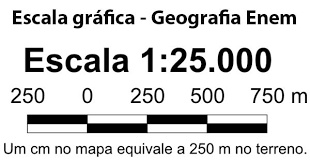
Como se lee, que significa esta escala y que tipo de escala es? 45:890 876
Texto
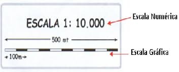
Esta es una escala gráfica, ¿Qué significa?
Selección Múltiple
¿Cuántos tipos de escalas de reducción hay?
Falso Verdadero
Hay 5 tipos de mapas para las escalas de reducción: Planos, mapas topográficos, mapas coreográficos, planisferios y mapamundis.